
How Does 911 Find Your Location? What Callers Should Know
“Just call 911, they can see your GPS” is advice you shouldn’t rely on. Emergency dispatchers may receive useful location information, but they don’t get a guaranteed, exact pin from every phone. A coordinate can also identify the right building without telling responders which door to enter.
So, how does 911 find your location? In the United States, it uses layers of information from your phone service, the wireless network, and supported handset technology. Your address, floor, room, and entrance instructions can turn that technical estimate into somewhere responders can reach.
Table of Contents
- What 911 Actually Receives When You Call
- How a 911 Call Gets Located, Step by Step
- Why Indoor Location Lags and How Floors Get Identified
- When 911 Gets No Usable Location
- How to Give Your Location During a 911 Call
- Set Up Your Location Before an Emergency
What 911 Actually Receives When You Call
911 doesn’t receive a GPS pin from every phone, and what arrives depends on how you make the call.
| Call type | What reaches the dispatch center | Typical precision |
|---|---|---|
| Landline | Address registered to the line | Street address |
| Wireless, Phase I | Callback number and the cell site or sector handling the call | Tower or sector area, potentially large |
| Wireless, Phase II | Latitude and longitude estimated from network or handset data | A coordinate estimate, not an exact doorway |
| Wireless with dispatchable location | Street address plus floor, unit, or room when available | Address-level, with interior detail |
| VoIP | Registered address, including an outdated address if it hasn’t been updated | Only as good as the saved address |
| Phone with no active service | No location; dispatch cannot call back | None |
Think of these as different kinds of location evidence, rather than a universal ranking. A correctly registered landline can provide a useful street address, while a wireless coordinate might be more useful on a trail. Neither automatically explains how to reach someone behind a locked interior door.
An address and a position aren’t the same thing
A registered address comes from a record associated with the telephone service. An estimated position comes from measurements intended to locate the device during the emergency. The distinction matters whenever a phone or internet telephone moves away from its saved address.
Dispatchable location adds the details a responder needs after arriving at the property. That might mean a particular apartment, office, or room, rather than just the building footprint on a map.
The call taker also needs to know whether the emergency is happening where the calling phone is located. If you’re reporting an incident somewhere else, say that immediately.
Start with your call type: Identify the row that matches your phone, then supply the location details that row doesn’t promise.
Treat the information reaching dispatch as a starting point for confirmation, not proof that responders already know exactly where you are.
How a 911 Call Gets Located, Step by Step
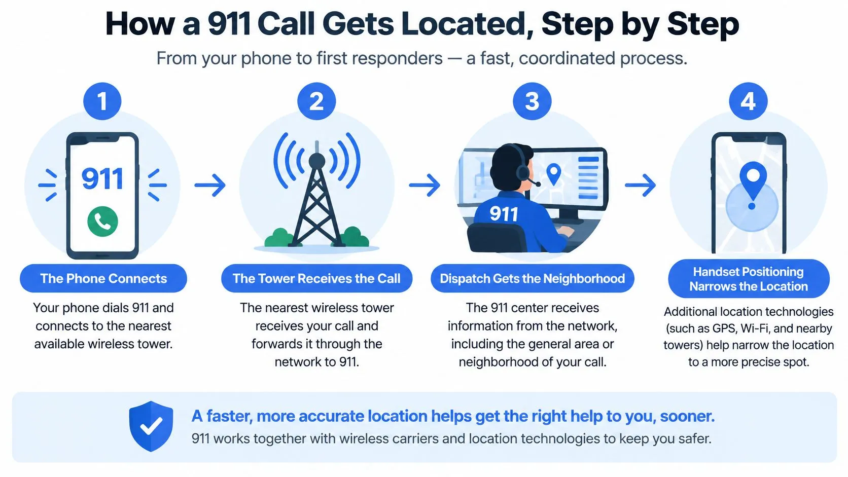
For a wireless call, the tower provides a useful starting area, while handset positioning can narrow the estimate toward a particular street or property. That’s an analogy, not a promise of neighborhood-level precision: the serving tower’s coverage area may extend well beyond the caller’s immediate surroundings.
The process combines call handling and location delivery, which can happen alongside each other rather than in a perfectly neat sequence.
-
Your phone connects to the wireless network. The carrier identifies the cell site and, where applicable, the sector handling the call. That gives the network a starting reference even before it has a more precise handset position.
-
The carrier supplies basic emergency information. Under the FCC’s Enhanced 911 framework, Phase I requires the caller’s telephone number and serving cell-site location after a valid request from the emergency center. The number provides a callback route; the cell-site information provides an initial geographic reference.
-
A more precise coordinate estimate may follow. Phase II adds latitude and longitude using network measurements, handset-derived positioning, or a combination. The FCC describes the general accuracy range as approximately 50 to 300 meters, depending on the technology used.
-
The network routes the call to an emergency center. Routing answers which center should handle the call, while positioning answers where help is needed. A call reaching a local center doesn’t mean that center already has the caller’s exact room or entrance.
-
The call taker reviews available location information. They ask you to confirm the location because an estimate and a spoken address can disagree. Their questions help establish whether the displayed information describes the emergency scene.
-
You supply the missing access details. A landmark, floor, room, or entrance description can make a broad estimate actionable. If you don’t know the address, explain what you can see rather than guessing.
Why GPS isn’t the whole explanation
GPS is one potential input, not the entire emergency-location system. The handset, carrier network, signal environment, and emergency center’s ability to receive the information all affect what becomes useful to the call taker.
That distinction also matters when considering a 911 dispatch app: supplementary information needs an emergency delivery path, not merely a visible map on someone’s phone.
What the dispatcher sees may be a broad area or a tighter coordinate estimate. Your answers help them turn that screen information into a confirmed destination.
Why Indoor Location Lags and How Floors Get Identified
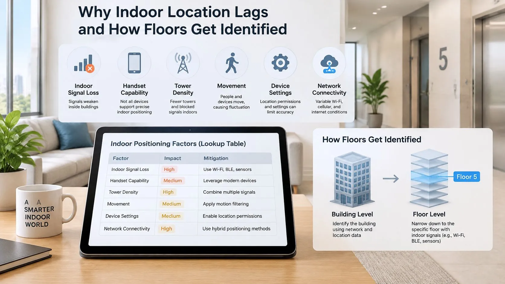
| Factor | Effect on location | What improves it |
|---|---|---|
| Indoors, deep in a building | Signals weaken, and an estimate may not identify the correct floor or wing | Dispatchable location, building reference points, Wi-Fi, or beacons |
| Handset capability | Unsupported devices may lack particular positioning or height measurements | A compatible handset and supported network technology |
| Tower density | Fewer available network reference points can leave a broader estimate | Additional network measurements and handset positioning |
| Movement | An earlier position may no longer describe where the caller is | Tell dispatch that you’re moving and describe your direction |
| Device settings | Permissions can limit app-based location sharing; emergency behavior isn’t identical across devices | Review relevant permissions without assuming they control every emergency-location function |
| Network connectivity | Weak connections can delay location updates | Give spoken landmarks and keep internet-calling address records current |
Indoors, a technically plausible coordinate can still leave responders with a practical search problem. Walls, building layout, handset support, and available reference points all affect whether an estimated position translates into a reachable room.
The illustration separates the horizontal map position from the problem of identifying a floor.
A map coordinate doesn’t identify a door
Say you’re inside a tall office building. A coordinate places you within its footprint, but the call taker still needs to distinguish the lobby from an upper-floor conference room. Even a good horizontal estimate doesn’t answer that question.
The FCC’s indoor location benchmarks require nationwide providers to achieve 50-meter horizontal accuracy or provide dispatchable location for at least 80% of wireless 911 calls. That’s a performance requirement across calls, not a guarantee that every caller receives a door-level position.
The remaining gap is operational. A point inside a property might be closest to a loading dock, while the usable entrance is on another street. Someone with breathing difficulty in an interior office needs responders directed to the office, not merely to the parcel.
Entrance information supplements location technology. It doesn’t replace carrier-provided emergency location or a direct emergency call.
The routes to identifying a floor
The FCC recognizes both dispatchable location and z-axis information. Dispatchable location describes a usable destination, such as an address with a floor, apartment, or office. Z-axis information estimates the handset’s vertical position.
Under the FCC’s vertical-location requirements, the z-axis accuracy metric is within plus or minus 3 meters of the handset for 80% of wireless E911 calls from z-axis-capable devices. Height information can help distinguish levels, but it isn’t automatically a labeled floor or room.
Buildings complicate that translation. A mezzanine, sloping site, or differently numbered lobby can make a measured height less intuitive than a plainly stated floor name. The call taker benefits from both the technical estimate and the building’s own labels.
This video provides additional context for understanding emergency-location technology.
Why deployment milestones don’t guarantee identical results
Requirements for vertical location were phased by geographic market, while dispatchable-location obligations recognize technical feasibility and cost. That helps explain why the available information isn’t identical across every device, building, and network.
The next challenge is making height information easier to interpret and evaluating environments separately. In March 2025, the FCC’s location-based-routing page described a proposal to require height-above-ground reporting and separate validation in dense urban, urban, suburban, and rural environments. A proposal isn’t an adopted guarantee, but it identifies the problem with relying on broad averages.
Strong performance in one setting doesn’t establish equally actionable performance elsewhere. A dense urban building and a rural property present different positioning and access problems.
Our location information may also be delayed, approximate, inaccurate, or unavailable because of device settings, environmental factors, network connectivity, GPS limitations, third-party systems, or technical constraints. No safety workflow should depend on a map pin being flawless.
Practical rule: State the floor, unit, and usable entrance aloud, even when your own map looks precise.
Give the building’s actual floor label and any useful access instruction. “Use the courtyard entrance beside reception” can answer a question that coordinates alone cannot.
When 911 Gets No Usable Location
A phone capable of placing an emergency call isn’t necessarily capable of delivering usable location or receiving a callback. According to the National 911 Program’s frequently asked questions, phones without active service don’t deliver the caller’s location, and the emergency center cannot call them back.
VoIP creates a different failure mode. An internet telephone can be used away from its saved address, so its registered physical address must be kept current. If the record still describes your former home, the call taker needs your present location immediately.
| Situation | Location dispatch may receive | What the caller should do |
|---|---|---|
| Active cell phone with service | Network and handset location, subject to accuracy limits | Give landmarks, floor, and access details |
| Phone with no active service | No location and no callback capability | State your location immediately; use a serviced phone if safely available |
| VoIP number used away from home | A registered address that may be wrong | Explain that you’re elsewhere and give the current address |
| Someone calling for another person | Information associated with the calling device, not automatically the victim | Give the victim’s address, floor, and nearest cross street |
| Caller cannot speak | Available technical location, without verbal confirmation | Keep the connection open if safe; use text-to-911 where available |
A shared location isn’t an emergency transmission
A family member seeing your route doesn’t establish that a dispatcher has received it. Passive location history, live sharing with a contact, and an active emergency transmission are different things.
A trusted contact should verify whether the displayed position is current and whether the emergency is happening there. An old pin can be useful background, but it shouldn’t be presented as a confirmed present location.
For people comparing an emergency response app, the important distinction is what reaches public safety during an escalation, rather than what stays visible to friends.
Reporting an emergency somewhere else
If you’re calling for a person in another city, begin by saying that the emergency is elsewhere. Give that person’s location before explaining your own whereabouts.
Try to obtain the address, building, floor, room, and nearby cross street. If you don’t know a detail, say so; don’t convert an uncertain map position into a confident address. The call taker can work with an explicit uncertainty more safely than an invented destination.
How to Give Your Location During a 911 Call
You don’t need technical vocabulary to help a dispatcher locate you. You need a clear location, the details needed to reach it, and honest answers about anything you don’t know.
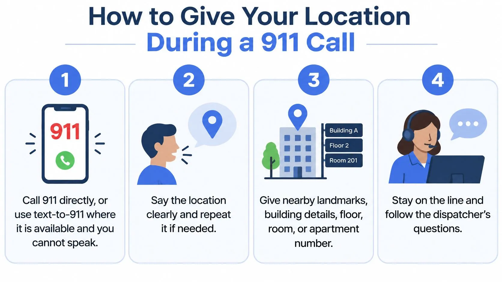
Use these actions as a practical sequence, while following the call taker’s instructions if they ask questions in a different order.
-
Call 911 directly. If you can’t speak, use text-to-911 where it’s available and safe to use. Don’t delay an urgent request while trying to perfect your phone’s location settings.
-
Say the address first. If you don’t know it, give the nearest cross street, a visible landmark, or the property’s posted identification. Don’t assume the call taker can see the map on your screen.
-
Give the interior and entrance details. Include the floor, unit, room, building wing, and entrance you used. Mention a locked gate or an entrance on another street if it affects access.
-
Say whether you’re moving. Describe your direction and current landmarks, or give the road and direction of travel if you’re in a vehicle. Don’t stop somewhere unsafe just to preserve a location estimate.
-
Answer the call taker’s questions. If speaking is difficult, follow any instructions they give for communicating. Use keypad responses only if the call taker requests them; don’t assume there’s a universal silent-call code.
-
Stay connected until you’re told to disconnect. The call taker may need to confirm an address, explain what to do, or ask about changing conditions. If the call disconnects, try again and explain that you were disconnected.
Avoid the shortcuts that create ambiguity
A business name alone may identify several branches or entrances. Add the street, municipality, and the part of the property where help is needed.
Don’t hang up just to check your map. Tell the call taker you’re unsure of the address and follow their guidance while you identify signs or landmarks.
Give what you know, label what you’re unsure about, and let the call taker guide the questions.
A useful practice sentence is: “I’m at [address], on [floor] in [room], use [entrance], the emergency is [brief description], and my callback number is [number].”
Set Up Your Location Before an Emergency
Choose today to check the phone and telephone services you use. A saved address, readable access note, and current contact list are easier to fix calmly than during an emergency.
Make the highest-impact checks first
-
Review location permissions. Keep the permissions needed for your chosen safety tools enabled, including precise or background location where required. Don’t assume that an app permission determines every part of carrier-provided emergency location.
-
Confirm your emergency address. Review the saved address for VoIP and Wi-Fi calling, and update it when your location changes. For workplaces installing internet phones, CloudOrbis VoIP deployment advice from CloudOrbis Inc. offers broader deployment context; make emergency-address management an explicit setup responsibility.
-
Check local text-to-911 availability. Learn how to compose an emergency text without sending a test message to emergency services. Don’t place a practice emergency call or text unless the local agency has explicitly arranged it.
-
Write down your first-to-call people. Keep their current telephone numbers somewhere accessible, and confirm that they know your address. A contact who knows the building entrance can provide useful context when you can’t.
-
Rehearse your location aloud. Practice saying the street address, floor, room, and usable entrance without searching through messages. Add access details to your household or workplace emergency notes.
Use supplementary tools without replacing the direct call
Our emergency-contact resources help people keep their first-to-call contacts written down and current. A safety app can supplement that preparation, but SOS and dispatch features aren’t substitutes for dialing 911 or the local emergency equivalent, and they don’t change what location the carrier sends.
For app-based sharing, our guidance on how to improve location accuracy can help you review the relevant setup. Keep a spoken address and access description ready even after checking permissions.
Pick the phone you use most, confirm its saved emergency address where applicable, and write down your first-to-call contacts today. Those are concrete preparations you can complete before you need help.
3rd-i offers live video, audio, and location sharing with selected contacts and trained Safety Agents, with emergency escalation through RapidSOS. Visit 3rd-i to explore how those tools can supplement your location and contact plan, while keeping a direct 911 call your first action in an emergency.