
How to Improve Location Accuracy on Your Phone
You open Maps and the blue dot is drifting across the street. Inside a coffee shop, it freezes near the wrong entrance. A rideshare driver circles the block because your pickup pin landed on the other side of the building. Your phone isn’t broken. It’s estimating your position from several imperfect signals, then trying to smooth the result while you move.
You can improve location accuracy in three places: device settings, the physical environment, and your own usage habits. Settings decide which signals an app may use. Buildings, trees, roofs, and vehicles decide how clearly those signals reach the phone. Your movement, phone position, and permission choices determine whether the app receives a fresh, useful fix or an old guess.
The practical advice below focuses on what really helps, why it works, and when it stops helping. It also draws a line between a sharper map dot and truly useful safety information.
Table of Contents
- Why Your Blue Dot Lies Sometimes
- Turn On the Right Location Settings
- How GPS, Wi-Fi, and Cell Work Together
- Move Your Phone to Get a Cleaner Fix
- Manage App Permissions the Smart Way
- When Settings Aren’t Enough for Safety
- Quick Fixes for Common Location Problems
Why Your Blue Dot Lies Sometimes
You open Maps and the blue dot slides across the street. Inside a coffee shop, it settles near the wrong entrance. A rideshare driver circles the block because the pickup pin landed on the opposite side of the building. Your phone is estimating your position from several imperfect signals, then smoothing the result as you move.
The phone combines satellite signals, nearby Wi-Fi networks, cellular information, Bluetooth clues, and motion sensors. Each source behaves differently. A building can block satellites, nearby Wi-Fi can improve an indoor estimate, and a change between cellular towers can shift the position shown on screen.
Outdoors with a clear sky view, modern smartphones can often produce a single-digit-meter position. A 2019 urban study found average horizontal accuracy of about 7 to 13 meters on an iPhone 6, while an earlier app study discussed in the same paper found average errors of 108 to 655 meters (urban smartphone location accuracy study). A later evaluation reported a 4.53-meter median horizontal error across smartphones and apps, with high-end devices averaging about 4 meters and lower-end models about 6 meters (2025 smartphone GNSS evaluation).
Those figures describe testing conditions, not every blue dot you see. Tall buildings reflect satellite signals, indoor walls weaken them, and the phone may temporarily depend more on Wi-Fi or cellular positioning. Fixes fall into three practical areas:
- Settings: Let the right app use precise positioning.
- Environment: Move toward open sky or stronger nearby signals.
- Habits: Hold the phone openly, wait for stabilization, and question a frozen position.
A key fob tracker, such as the 3rd-i key fob tracker, solves a different problem. It helps locate an attached item through a nearby-device network, but it cannot replace the phone’s live navigation position.
Practical rule: A blue dot is an estimate with uncertainty, not a person standing on a perfectly measured map point.
Turn On the Right Location Settings
The fastest way to improve location accuracy is to stop an app from using a deliberately vague position. Privacy settings are useful, but a navigation app that only receives an approximate area can’t guide you reliably to a specific entrance.
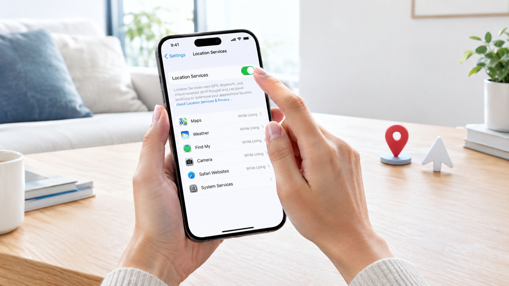
iPhone settings
Use this sequence:
- Open Settings.
- Tap Privacy & Security, then Location Services.
- Keep Location Services turned on.
- Select the app that needs accurate positioning.
- Choose While Using the App, or Always only when the app needs background tracking.
- Turn Precise Location on.
Precise Location is an app-level control. Location Services can be active while an individual app still receives an approximate position. Maps, rideshare apps, turn-by-turn navigation, and safety tools need precision. A news app usually doesn’t.
Android settings
On Android, menu names vary by manufacturer, but the useful path is generally:
- Open Settings.
- Tap Location.
- Turn on Use location.
- Open the device’s location accuracy settings and choose the highest-accuracy option available.
- Enable Wi-Fi scanning and Bluetooth scanning if your phone presents those controls.
- Check the target app under app permissions and allow precise location while in use, or background access only where necessary.
Wi-Fi scanning doesn’t mean your phone must connect to an unfamiliar network. The device can use nearby network signals as location clues without joining them. That helps indoors, where satellite reception is often poor.
Battery saving and broken permissions
Battery Saver is fine for a short walk when you only need occasional map checks. It can interfere with continuous updates, background tracking, and live safety feeds, so turn it off for an active navigation session or a safety journey.
If one app stays wrong while other apps work, reset that app’s location permission. Set it to Never or Don’t allow, close the app, reopen it, and grant access again. Then check that precise location and background permission haven’t been disabled by the operating system’s unused-app controls.
How GPS, Wi-Fi, and Cell Work Together
Your phone’s location is a fused estimate, not a single reading. GPS and other GNSS satellites provide the main outdoor position, but their signals are weak by the time they reach the ground. Buildings, bridges, trees, and indoor ceilings block or reflect them, creating the familiar urban-canyon drift.
Wi-Fi contributes a different kind of clue. Apple and Google maintain databases associating nearby Wi-Fi networks with physical locations, so a phone can recognize that it is near a known network even when it isn’t connected to that network. This is especially useful in buildings, where Wi-Fi clues can arrive faster and more reliably than satellite signals.
Cellular positioning is a fallback. A phone can use tower information and signal timing to estimate a broad area, but that estimate may be far less precise than a fresh satellite fix. Emergency systems have historically struggled with wireless location uncertainty. A dispatcher survey found that 97% of call centers had received a wireless emergency call from someone unable to explain their location, while 48% said they only sometimes, rarely, or never received accurate Phase II latitude-longitude information (survey of emergency dispatchers and wireless location).
Bluetooth and motion sensors fill smaller gaps. Bluetooth beacons can provide short-range hints, while the accelerometer, gyroscope, and compass help the phone infer movement and direction between stronger fixes. A Tile Mate Bluetooth tracker is useful for finding tagged belongings, but it isn’t a substitute for live phone positioning.
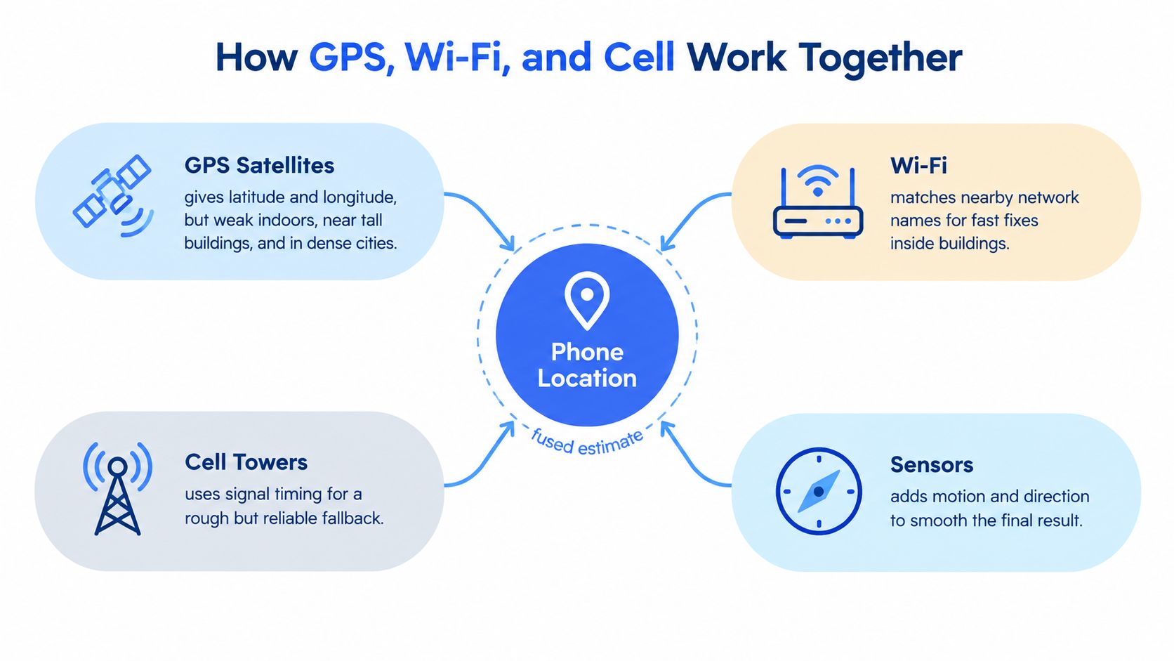
This explains why a rideshare position can drift during a journey. The phone may alternate between satellite fixes, Wi-Fi observations, cell estimates, and motion predictions. Step outside and the system can suddenly replace a broad indoor estimate with a stronger satellite position, so the dot appears to jump.
Move Your Phone to Get a Cleaner Fix
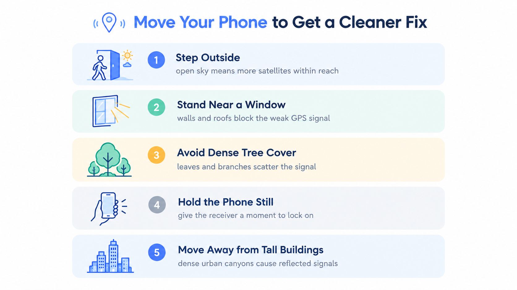
If Maps freezes outside a building, do not keep tapping the location button. Change the phone’s view of the sky. GPS signals are weak indoors, so step outside or stand beside a window, hold the phone with the screen facing upward, and give it a short period to acquire a fresh fix.
Walls, roofs, dense foliage, and tall buildings interfere with satellite signals. Smartphone GNSS accuracy can deteriorate sharply in crowded urban areas with many obstacles. Reflected signals may place the blue dot across the street or make it jump between nearby positions. Moving to a clearer spot addresses the cause instead of forcing the app to recalculate the same poor estimate.
Five physical changes that help
- Step outside. Open sky gives the receiver access to more satellites.
- Stand near a window. Glass is usually better than several interior walls and a concrete roof.
- Move away from tall buildings. Reflections in a downtown canyon can create a false position.
- Avoid dense tree cover. Leaves and branches weaken and scatter the signal.
- Hold the phone still. A stable device gives the receiver time to settle.
If the blue-dot cone points the wrong way, make a slow figure-eight with the phone. This refreshes compass calibration and improves heading display, although it cannot overcome a blocked satellite view. Remove a thick case, metal plate, or strong magnetic accessory if the problem started after installing it.
For a cold navigation start, keep the phone screen-up with a clear sky view for roughly 30 seconds before driving away. Do not bury it under clutter in a hot car mount, especially while charging. Heat and poor antenna exposure can make a weak fix less stable. Live safety apps also need a reliable position, so device settings alone cannot compensate for heavy obstruction or a failing receiver.
Manage App Permissions the Smart Way
Accuracy and privacy aren’t opposites. The smart approach is to give each app the least access that still supports its actual job.
A weather app may need your region. A map needs precise positioning while you use it. A rideshare app needs a reliable live position during pickup and the trip. A game or shopping app usually doesn’t need continuous background tracking at all.
Use While Using the App as the default. Choose Always only for a service that must continue updating when the screen is locked or the app is in the background. Review the location permission list regularly under Privacy and Location Services on iPhone, or Location and app permissions on Android. Revoke access from apps you no longer use.
Turn off precise location for apps that only need a city or general region. That prevents unnecessary detail from being shared while preserving the app’s basic function. Also review background activity controls, because a neglected app can keep requesting location when you don’t need it.
The exception is a live safety journey. If a safety contact needs a continuous route, a check-in trigger, or a live stream to start while your phone is locked, restricting background access can make the feature unreliable. Services such as 3rd-i live location sharing use live location alongside route and safety communication, so the relevant permissions and notifications need to remain active during the journey.
Don’t switch off Wi-Fi or Bluetooth scanning blindly. Nearby network and beacon observations can help indoors, and Wi-Fi scanning doesn’t require joining a network. If battery use is your concern, test the setting during a normal day and look at the phone’s battery report rather than assuming every scan creates a serious drain.
When Settings Aren’t Enough for Safety
A precise blue dot doesn’t tell you whether someone is safe. It tells you where the phone estimates its position, not whether the person is inside a building, on the wrong floor, approaching the wrong entrance, or unable to answer a call.
That distinction matters in a hospital, campus, transit hub, warehouse, or large apartment complex. Even a small coordinate error can send a helper to the wrong side of a building. Indoor positioning research shows why map context matters: a study of indoor emergency workflows reported that detailed indoor maps and routing could reduce response time by about 24% (indoor emergency mapping research). The operational gain comes from routing and context, not merely from displaying more decimal places.
A sharper dot in the wrong entrance is still the wrong answer.
For a routine walk, better settings and a clear sky may be enough. For a late-night commute or lone-worker journey, useful safety information can include:
- A live route: Shows whether the person is moving toward the expected destination.
- An entry point: Tells a helper which door or access point to use.
- Live audio or video: Adds scene information that coordinates cannot capture.
- A check-in response: Confirms that the person can respond, rather than assuming the phone is still with them.
- Escalation context: Gives trained monitors or emergency dispatch more than an isolated map point.
That is why device settings are only the foundation of a safety workflow. Improve location accuracy on the phone, then pair it with a system that can confirm what is happening when a coordinate lacks enough detail. The goal isn’t perfect geometry. The goal is actionable information at the moment someone needs help.
Quick Fixes for Common Location Problems
Treat a bad location as a diagnosis problem. Don’t jump straight to a factory reset or buy a new phone before checking the signal, permissions, and app behavior.
Match the symptom to the first fix
| Symptom | Fastest Fix to Try First | Settings Involved |
|---|---|---|
| Blue dot is stuck | Step outdoors, make a slow figure-eight, toggle Airplane Mode briefly, then reopen Maps | Location Services, Precise Location, compass access |
| Dot lands on the wrong street | Enable Wi-Fi scanning and temporarily disable a VPN that changes regional routing | Wi-Fi scanning, VPN, high-accuracy location |
| Dot jumps between floors indoors | Use available Wi-Fi positioning and confirm the app has precise location access | Wi-Fi scanning, Precise Location, app permissions |
| GPS drains the battery | Restrict background access to essential navigation and safety apps | Background location, Battery Saver |
| Rideshare pickup is wrong | Move into open air and hold the phone up long enough to obtain a fresh satellite fix | Location Services, Wi-Fi scanning |
| Heading points backward | Perform a figure-eight and remove magnetic accessories from the case | Compass calibration, Bluetooth or magnetic accessories |
A VPN can affect regional results, but it usually isn’t the main cause of a physically wrong GPS coordinate. Test with it disabled so you can separate an app’s regional interpretation from the phone’s actual sensor fix.
Google Maps can show location and timeline-related accuracy information through its account and location controls. Apple’s significant locations history can also be reset when its suggestions become stale. These tools help clean up historical assumptions, but they won’t overcome a roof or an urban canyon during a live trip.
Use a 30-second diagnostic routine
- Step into open sky or beside a clear window.
- Toggle Airplane Mode on, wait briefly, then turn it off.
- Reopen Maps and check the location accuracy indicator.
- Confirm precise location and Wi-Fi scanning are enabled.
- Keep the phone still until the position stops moving.
- If one app remains wrong, reset only that app’s permission.
Don’t trust a reported accuracy radius without context. One controlled comparison measured smartphone GPS error at 2.57 meters, versus 37.19 meters for network location, while the network provider reported 55.56 meters (GPS accuracy guidance and validation). The lesson is simple: a number shown by the phone is an estimate, not ground truth.
For advanced systems, sensor fusion beats GPS alone. Combining GNSS, Wi-Fi, cellular signals, inertial sensors, and motion constraints can reduce drift, while indoor positioning can use radio measurements and step information to narrow movement. If the situation is safety-critical, pair the best available coordinate with route, entry, and communication context rather than relying on the map dot alone.
Use the settings above to improve location accuracy during everyday navigation, then use 3rd-i when a person needs more than a coordinate. It combines live location with video, audio, route sharing, check-ins, Safety Agent monitoring, and emergency escalation context for walks, rideshares, campuses, and lone-worker journeys.