
How to Track a Route Live: Sharing, Check-Ins and SOS
You’re heading home after dark, and the route looks fine on your phone. Your friend has agreed to watch, but their screen shows an old dot because background location wasn’t enabled. You think someone’s following your progress; they don’t have enough information to tell whether you’re moving.
Learning how to track a route means setting up more than a map. You need a working live feed, someone who knows what to watch for, and an agreed response when a check-in or location update doesn’t arrive.
Table of Contents
- What a Live Route Needs Before You Leave
- Set Up Your Squad and Start a Live Route
- Check-Ins That Work When You Cannot Text
- Why a Route Dot Can Drift or Freeze
- What to Do When the Route Goes Silent
- Escalation Options from Text to 911
What a Live Route Needs Before You Leave
A live route starts with permissions. In the 3rd-i app, precise location, including background location, enables Trip Mode, SOS and location sharing with your Squad. Denying location access prevents Trip Mode, precision SOS location sharing and related Safety Agent functions from working as intended.
Open your phone’s Settings, find the app and check its permissions individually. Location permission answers where you are; camera and microphone permissions give watchers context that a dot can’t provide. Your contacts should also check their notification settings, particularly if they use Do Not Disturb overnight.
Permissions a Live Route Depends On
| Permission | What it powers | What happens if it is off |
|---|---|---|
| Precise location | Trip Mode, SOS and location sharing with your Squad | Trip Mode and precision SOS location cannot work as intended |
| Background location | Route keeps updating while the phone is locked | Route may stop updating when the screen is off |
| Front and rear camera | Live video for watchers, dual-camera streaming | Squad sees the route without video |
| Microphone | Live audio and Request to speak | Watchers cannot hear you or join audio |
| Critical Alerts | Urgent alerts that reach contacts through Do Not Disturb | Urgent alerts can be silenced at night |
Background access isn’t the same as leaving the screen on. Test with your phone locked, because that’s how you’ll probably carry it while walking. For audio, remember that a watcher’s Request to speak requires your approval before they join.
Test the Entire Trip
- Start nearby. Choose a familiar corner as your destination and begin a short trip.
- Verify remotely. Ask a Squad member to confirm that your route updates on their phone, not just yours.
- Finish deliberately. Reach the destination and confirm that the arrival alert reaches your contact.
If you’re riding rather than walking, include phone power and carrying arrangements in your preparation. Rider 18’s e-bike adventure packing guide is a useful companion for planning what to take.
Complete this test before relying on tracking for a real journey. A permission problem is easier to diagnose in daylight than during a late walk.
Set Up Your Squad and Start a Live Route
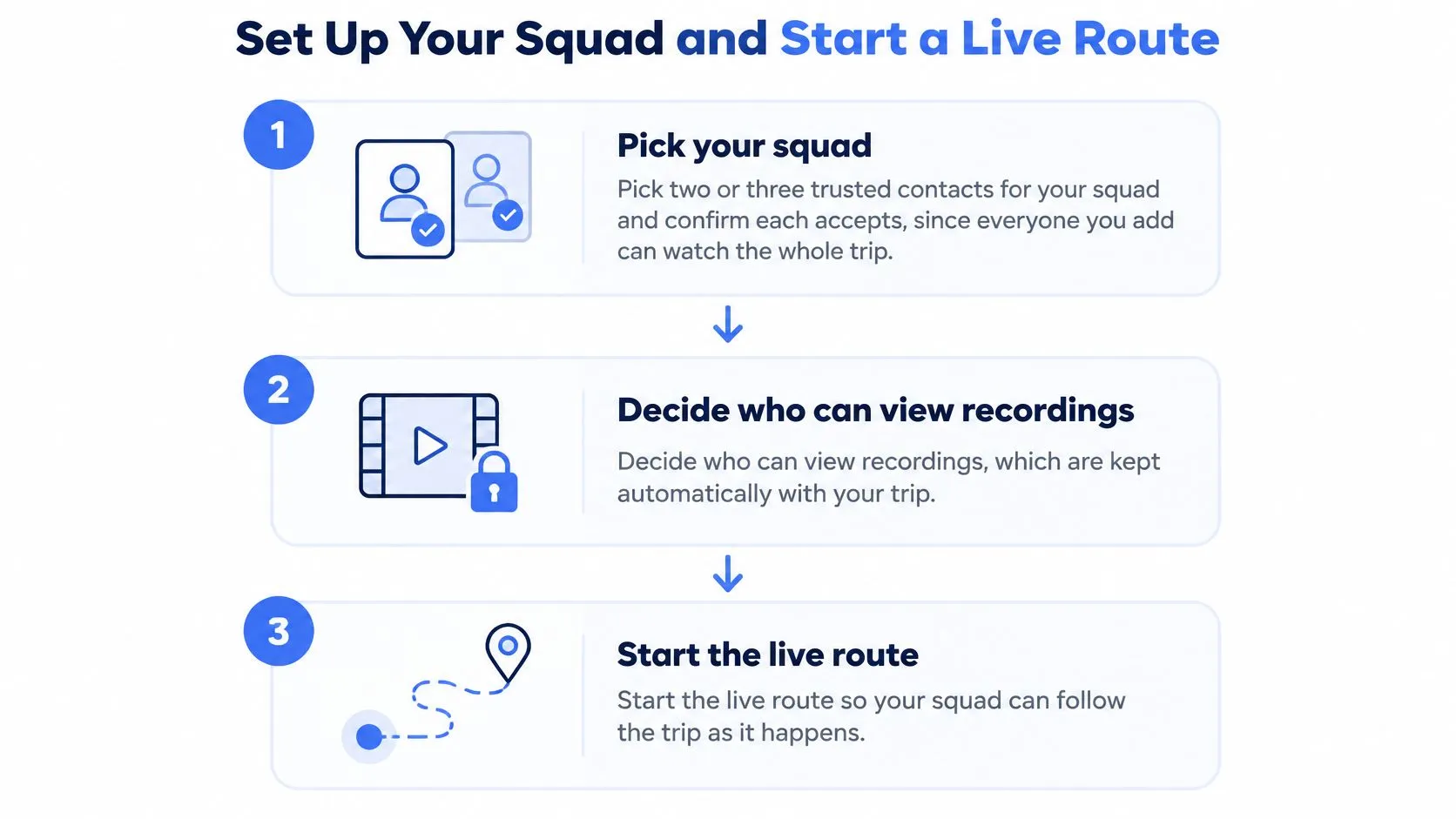
Choose contacts who can watch or respond during your trip. A trusted person who’s asleep, driving or working without their phone isn’t an available watcher. Pick a small Squad, confirm that each person accepts, and name a lead contact so everyone doesn’t assume someone else will act.
Everyone you authorize can follow the trip. Explain what that includes before sharing: your route, video and potentially sensitive details about where you live, work or spend time.
The setup follows this sequence.
Agree on Access Before Starting
Decide who should be able to view recordings, which are kept automatically with transcription and summaries. Permission to watch a trip deserves the same care as permission to see its recording afterward.
You can turn GPS tracking off at any time, which stops the third party tracking your location. Ghost mode lets you step temporarily off the map. Squad members may track your location while the app is in use and with your permission, so tell your lead contact if you intentionally stop sharing.
For workplace journeys, separate availability from surveillance. Workers start their own trips and choose their sharing circle; employers can’t start trips for them or view their individual location between trips. Managers coordinating travel can also consult My Safety Manager’s guide to getting more from fleet software when organizing their wider transport workflow.
Start With a Watcher, Not Just a Destination
- Open the app as you leave. Tap Go Live to send your route, camera and audio to the people you picked.
- Share access where needed. Send your trip link to a trusted contact without the app so they can follow the route and video from a browser. Treat that link as private.
- Set your destination. Trips sends notifications when you reach the desired location or end the trip early.
- Check the watcher count. Confirm that the expected watcher has joined. An invitation sent isn’t confirmation that someone is watching.
- Choose a useful camera view. Use the rear camera when the concern is behind you, or the front camera when showing your face gives better context. Don’t compromise your footing to frame a shot.
- Make access easier. Add the Lock Screen widget so Go Live and SOS are readily available.
This video shows the live-sharing workflow.
A healthy start has an updating route and the expected watcher present. Keep the phone secure rather than holding it out continuously, and stop somewhere safe if you need to change settings.
Before departure: Agree who responds to a missed check-in. A visible watcher count doesn’t assign responsibility.
End the trip when you arrive, then make sure your lead contact understands that monitoring is finished.
Check-Ins That Work When You Cannot Text
Typing a detailed update while crossing roads, boarding a vehicle or carrying equipment is awkward. While driving, don’t handle the phone to answer a message. A check-in should reduce distraction, not introduce another task that competes with getting somewhere safely.
Our check-ins appear as a nudge on the map. You can answer with a location, a stream or a status in one tap. A short prompt such as You good? works during a walk; Home yet? fits an expected arrival.
Match the Nudge to the Journey
Movement detection prompts can operate within hours you set, such as a lone-work shift. Keep those hours relevant so a prompt outside the journey doesn’t create unnecessary concern. Use the check-in safety app guide to plan how nudges fit your routine.
Check-in plan by situation
| Situation | Nudge to send | Watcher response if no reply |
|---|---|---|
| Late walk | You good? at agreed intervals | Call or text the Safety Agent if the reply is missing |
| Rideshare | Home yet? near expected arrival | Check the route and arrival alert before escalating |
| Campus or commute walk | You good? at the midpoint | Have the designated watcher confirm the route on the map |
| Lone-work shift | Movement detection prompt within set hours | Check status and last reliable location, then call |
When something feels wrong during a live trip, you can text a Safety Agent. That’s useful when you can type discreetly but can’t comfortably speak. Don’t interpret text availability as a reason to delay an emergency call when there’s an immediate threat.
Give Silence a Defined Response
A missed check-in is a signal to investigate, not proof of harm. Before calling, the watcher should inspect the last reliable position and its timestamp, then consider whether the traveler can safely answer.
Connectivity also deserves preparation. If your journey involves unfamiliar calling arrangements, SwiftNet Wifi’s Starlink calling guide provides additional reading, but test your actual phone’s calling options rather than assuming a connection will be available.
For your next walk, schedule a departure-to-midpoint check-in and an arrival check-in. Name the watcher responsible for following up, and agree how long an unanswered nudge should remain open before they call.
Why a Route Dot Can Drift or Freeze
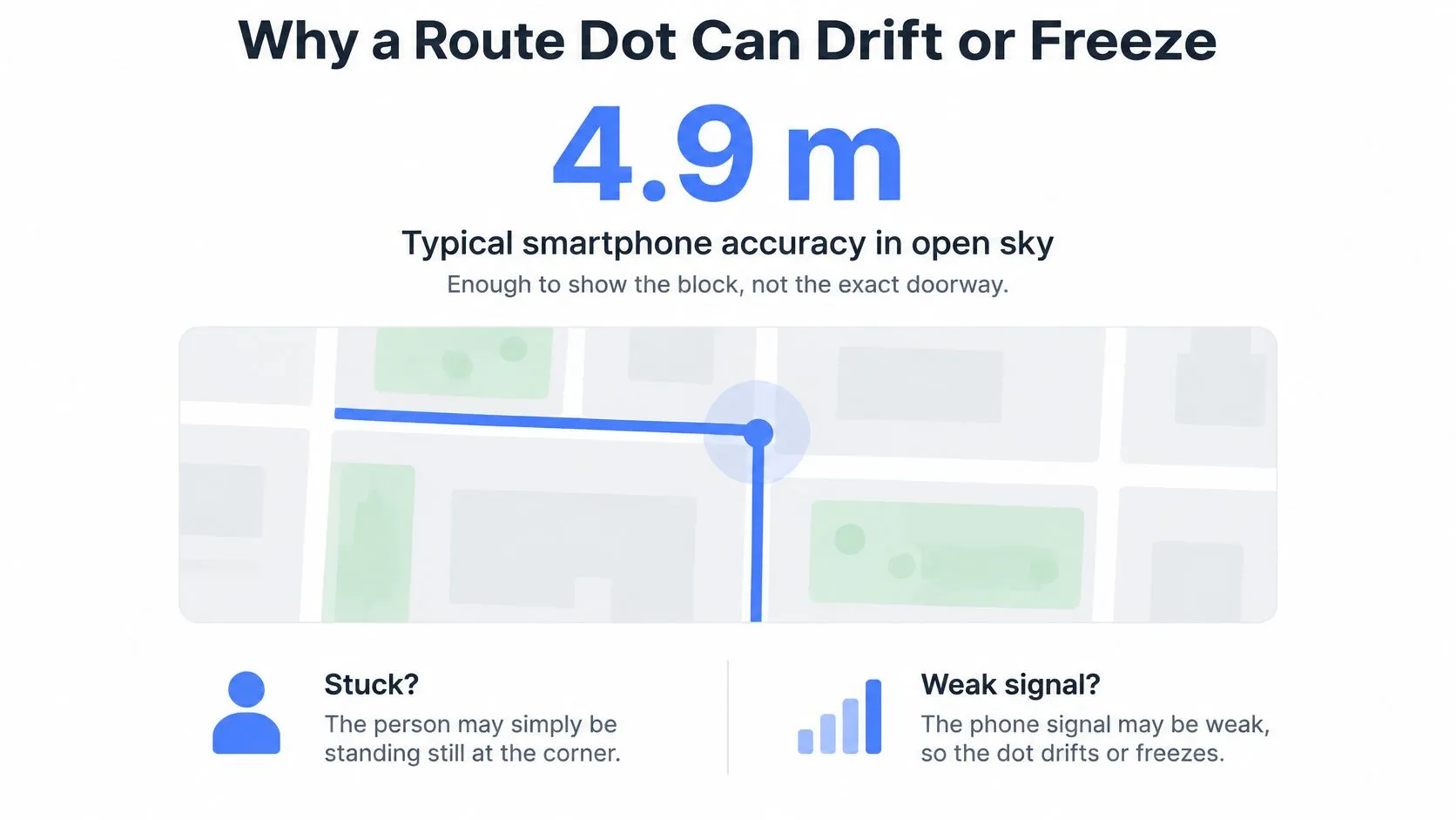
A dot stops at a corner. The traveler could be waiting to cross, standing inside a shop or moving beyond the last reported position. The dot alone can’t tell you which explanation is right.
According to the U.S. government’s GPS accuracy guidance, GPS-enabled smartphones are typically accurate within a 4.9-meter radius under open-sky conditions. That can identify a block or building area, but it doesn’t reliably establish the correct doorway, sidewalk or floor.
This illustration shows why a stationary dot needs interpretation.
Separate Position From Freshness
Tall buildings can block or reflect satellite signals. Tunnels, underground garages, indoor destinations and dense trees can also make positioning less reliable. A phone may still display the map even when it hasn’t obtained a useful new position.
Read last reliable location as the most recent position you have reason to trust, not the newest marker drawn. Read age of fix as how long ago the phone measured that position. If the interface doesn’t expose those labels, use the available timestamp and treat missing freshness information as uncertainty.
A smooth route line isn’t proof of continuous measurement, either. Stanford-hosted map-matching work describes inferring a network path from noisy location observations; the displayed line can therefore represent a plausible path rather than every step measured.
A fresh-looking map is not necessarily a fresh location. Check the timestamp before interpreting the route.
Run Checks That Add Context
- Ask for a landmark. A cross street, shop sign or entrance name can distinguish nearby places better than arguing over the dot.
- Compare with the intended route. Look for a plausible turn or destination, but don’t assume every apparent deviation is real.
- Send a nudge after unexplained stillness. Give the traveler a low-effort way to confirm their status before drawing conclusions.
Use our location accuracy guidance when troubleshooting device settings. Increasing update frequency won’t, by itself, resolve blocked signals or an incorrectly inferred path.
In a dense area, confirm a landmark when possible. If other evidence indicates danger, don’t wait for a cleaner GPS reading before seeking help.
What to Do When the Route Goes Silent
Your contact was moving, then the updates stopped. Start by identifying what disappeared: the location feed, the video, replies, or the entire session. Those are different observations, and recording the distinction helps you explain the situation without turning an assumption into a fact.
Silence is neither an arrival confirmation nor proof of an emergency. The response should reflect the trip’s context, the agreed check-in plan and any warning signs already present.
Match the Failure to a Useful Action
- Forgotten start. If no session appeared, contact the traveler through your agreed channel. Prevent a repeat by pairing departure with the habit of tapping Go Live before leaving.
- Dead battery. You can’t restore a powered-off phone remotely. Carry a charged power bank and compatible cable when the journey may outlast the phone’s available charge.
- Dead zone. Updates may resume when connectivity returns, but don’t assume they will immediately. Keep the journey open as unresolved until you receive fresh information.
- Changed vehicle or travel mode. Tell the watcher before switching when practical. End the old trip and start a new one if that makes the changed journey clearer, then confirm the watcher has rejoined.
Don’t repeatedly send messages that require long replies. If you can’t type safely, use a one-tap response when you’re able; if you’re the watcher, leave a clear request that’s easy to answer.
Read the Evidence Before Calling
Check the last reliable location, the age of that position, and when the app last received an update. These aren’t necessarily identical: a newly received message can contain an older location fix. Where the interface provides only one timestamp, don’t infer the others.
European Commission documentation on emergency caller positioning distinguishes positioning methods with substantially different precision. A fallback location shouldn’t automatically receive the same confidence as a good satellite fix.
Watcher’s note: Write down what you know, when you learned it and what remains unconfirmed.
If the traveler answers, ask for a recognizable landmark and whether their travel plan changed. If they don’t, follow your agreed call procedure and assess the surrounding evidence. Threatening audio, an explicit request for help or another immediate danger warrants escalation without waiting for location recovery.
Escalation Options from Text to 911
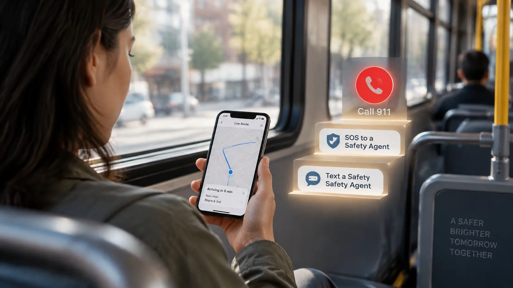
Choose the response that matches the evidence, not whichever button feels least awkward to press. A delayed check-in with an otherwise ordinary journey calls for a different response from a person reporting a threat. You don’t have to complete every rung before seeking emergency help.
Keep the controls familiar before traveling.
Choose Who Needs the Information
- Text a Safety Agent. During a live trip, explain what feels wrong and what kind of response you need. Include a landmark if the map position looks questionable.
- Trigger SOS. Our SOS alerts trained dispatchers with your live stream and real-time location. A Safety Agent can see the stream, hear the audio and track the GPS position in real time, then escalate to 911.
- Use Emergency for a Friend. The emergency alarm goes to the 911 center covering your friend’s location, with their location passed on. If your friend is live, their stream is sent; otherwise, their last known location is sent.
Our 24/7 security monitoring overview explains the human monitoring option. By using SOS or dispatch, you authorize information sharing, including location where applicable, with RapidSOS and public safety responders.
Describe Location Without Overstating It
Give responders the position shown, its timestamp and any confirmed entrance or landmark. Real-time GPS access doesn’t remove measurement uncertainty.
Accuracy by condition
| Condition | Typical accuracy | What the dot can show |
|---|---|---|
| Open sky | Within about 4.9 m radius under the government guidance described earlier | Block, road or building area |
| Urban canyon | Errors average about 15 m in smartphone positioning work summarized in the FCC-hosted emergency-location white paper | Possibly the wrong side of a street |
| 3D-mapping GNSS method (one study) | About 1.5 m in open sky in a smartphone study available through OSTI | A closer horizontal estimate in tested conditions, not a guaranteed entrance |
| Indoors or underground | No reliable numerical estimate for the particular fix | A stale, displaced or unavailable position |
The study result isn’t a promise of what your phone or app will display. For a friend who isn’t live, explicitly describe the supplied position as last known, not current.
The app isn’t a substitute for calling emergency services. If you have a phone in hand and face an immediate threat, call 911 directly. Before your next walk, agree which situations call for a nudge, an Agent conversation or emergency assistance.
3rd-i offers live route, video and audio sharing with selected contacts, plus Safety Agent support and emergency escalation. Visit 3rd-i to prepare your sharing circle, test a short trip and agree on a check-in response before your next late walk or rideshare.